SuspSedSense - Smart water turbidity sensing in rivers for identifying sediment sources
Dates: 2020-2024
Funding: ETH Grants
PhD Students: external page Jessica Droujko
Dissertation: research-collection (2024)
Contact: Peter Molnar, Daniel Farinotti
Fine sediment carried in suspension can be the dominant type of sediment transport in many rivers systems, especially in semiarid climates. Also in Alpine climates, fine sediment production varies greatly in space and time, and prediction of sediment fluxes at catchment outlets relies on accurately identifying sediment sources. In this research we aim to contribute to fine sediment prediction by (a) developing new sensing methods for turbidity measurement for multisite applications; (b) analysing the sediment concentration variability in space and time, identifying sediment sources; and (c) applying our concepts to several rivers in Europe as examples.
a) New multisite turbidity sensing

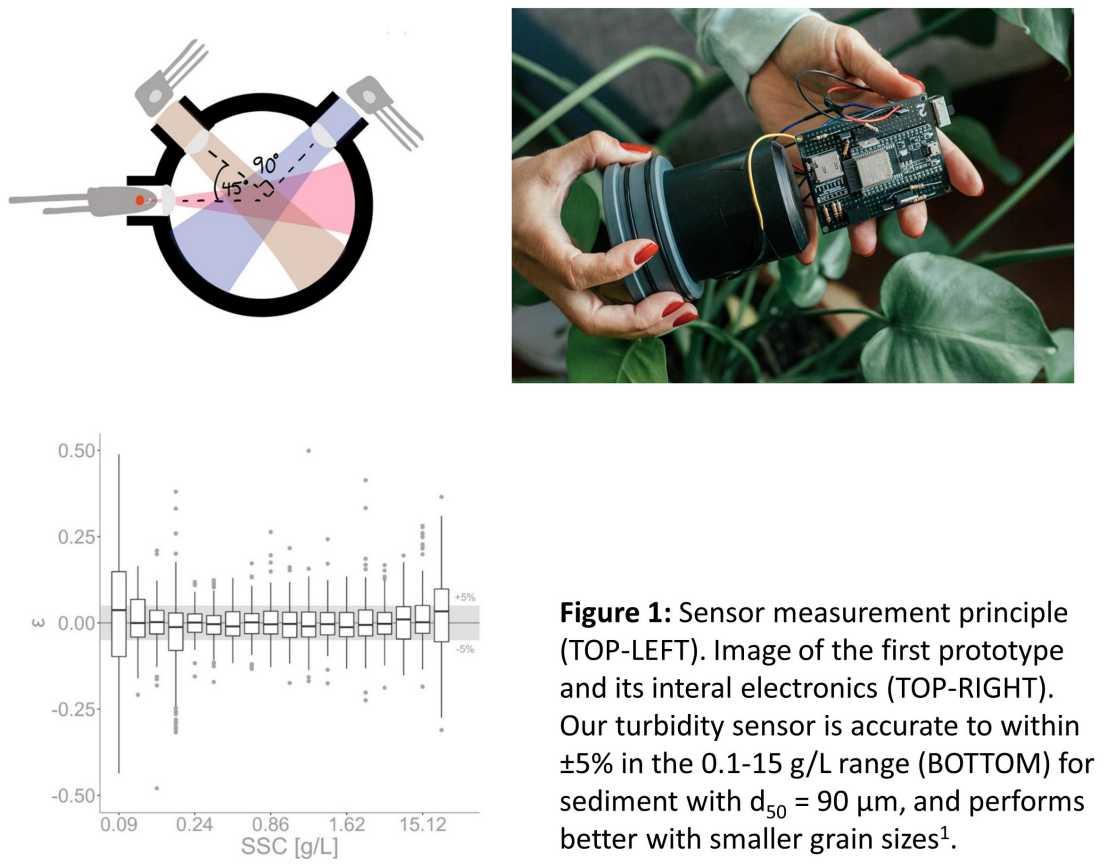
We have developed a low-cost, open-source turbidity sensor for distributed (multisite) sensing along a catchment river network. The working principle of the sensor is to illuminate a sediment-laden water sample with a light source and measure the amount of light scattered, at various angles, by detectors (Figure 1). The first and second prototypes can be seen in Figures 1 & 2. In this research, we design a smart sensor that is cheap to construct, yet provides the possibility on many replicates installed in rivers. The aim of the first prototype was to build a sensor that has high dynamic range, error compensation (due to water, colour, and attenuation), low sensitivity to the bandwidth of the optical source, and high reliability. It was lab tested in mixing tank experiments and you can find more information in our external page Sci. Rep. article. The aim of the second prototype was to build a sensor that is completely open-source and that anyone is able to replicate. This version was entirely 3D printed with a hobby printer (Prusa I3 MKR3) and we designed a custom PCB that stacks on top of an ultra low-power Arduino MKR 1310, for stability and so that the sensor is programmable in Arduino IDE. This work is published in external page HardwareX.
1Droujko, J., Molnar, P. (2022) external page Open-source, low-cost, in-situ turbidity sensor for river network monitoring. Sci Rep 12, 10341, https://doi.org/10.1038/s41598-022-14228-4
2Droujko, J., Kunz Jr, F., & Molnar, P. (2023). external page Ötz-T: 3D-printed open-source turbidity sensor with Arduino shield for suspended sediment monitoring. HardwareX, 13, e00395.

b) Sediment concentration variability in space/time

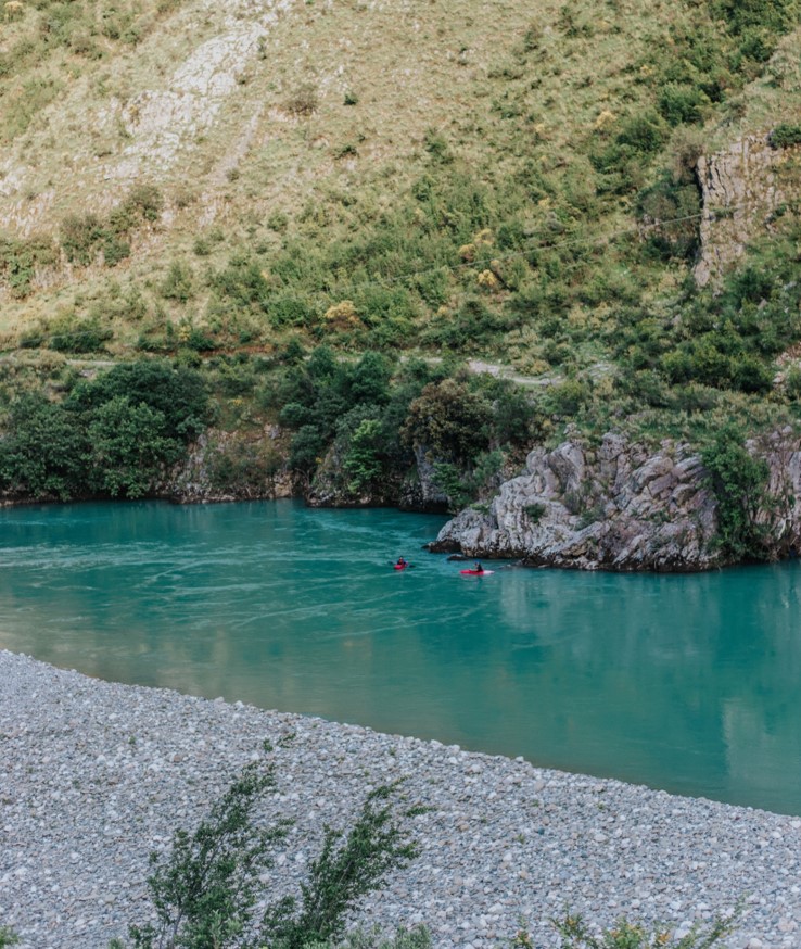
A single sensor at a basin outlet yields a basin-integrated picture of sediment fluxes. To obtain a full spatial perspective on possible sediment sources, sinks, and pathways within a catchment, higher spatial- and temporal-resolution data is necessary. We have attempted to obtain such data on the Vjosa river in Albania, one of the last intact large river systems in Europe. We did this by combining data extracted from Sentinel-2 satellite images with the data from four commercial turbidity sensors that were installed at various locations along the main stem of the river. We developed a workflow to estimate river turbidity profiles from Sentinel-2 images including atmospheric, cloud cover, and deep water corrections, for the period May 2019 to July 2021 (106 images) and this workflow can be found in our external page latest preprint. Our methodology was supported by lagrangian kayak-derived river profiles, which were measured with a turbidity probe attached to the bottom of a kayak. Sediment sources and sinks could be identified and quantified from the river turbidity profiles, both for tributaries and within the reaches of the Vjosa. Finally, we used the data to estimate the mean annual fine sediment yield at Dorez at ~2.5 ± 0.63 Mt/y in line with previous studies, which reveals the importance of the Vjosa River as a sediment source into the Adriatic Sea. This work presents a proof of concept that open-access high-resolution satellite data has the potential for suspended sediment quantification not only in large water bodies but also in smaller rivers.
IN COLLABORATION WITH external page FLUVIAL ECOSYSTEM ECOLOGY LAB (Prof. G Singer)
c) Creating a distributed network in various catchments
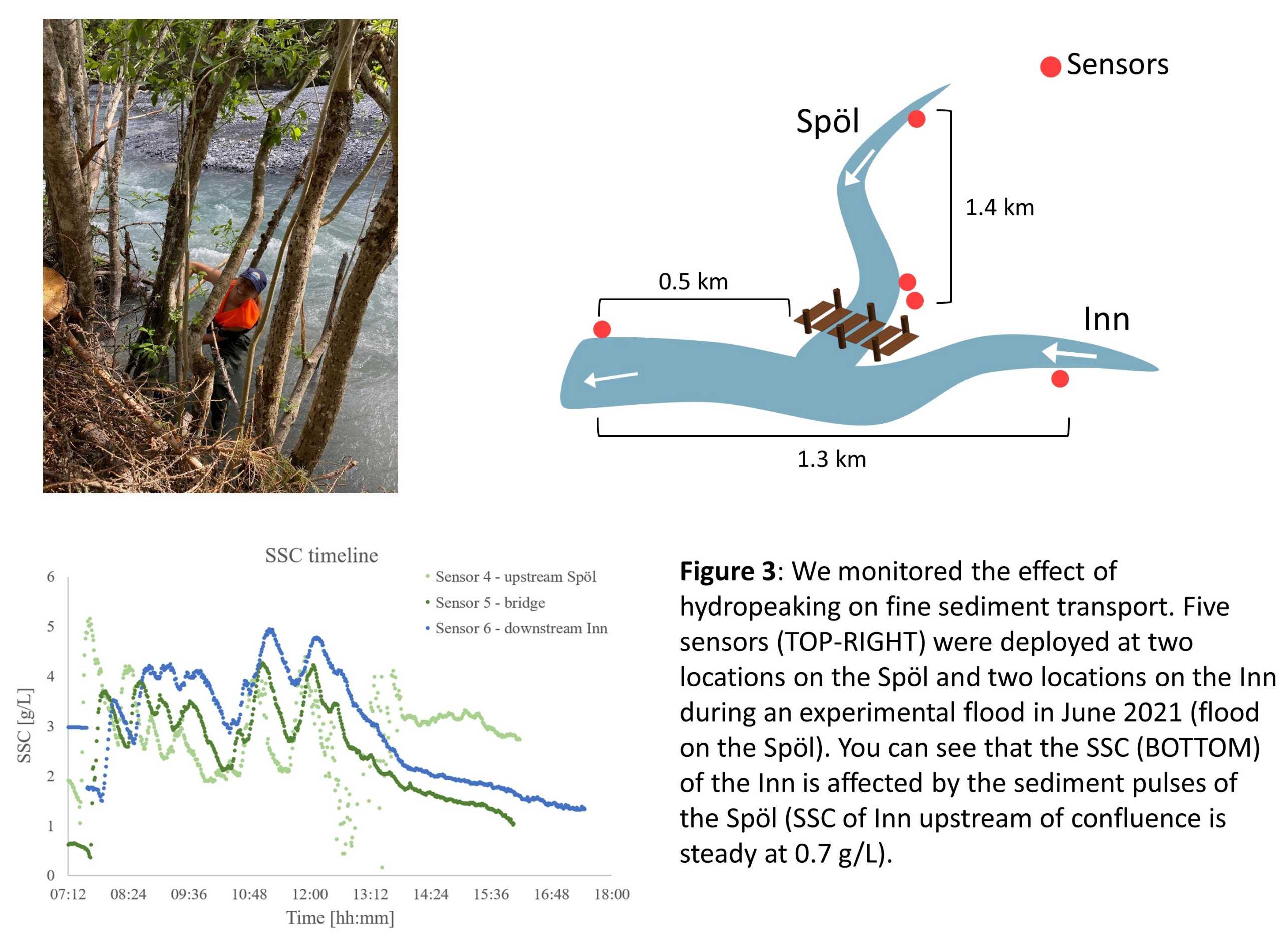
Looking to our first two projects as inspiration, we have started to build a small network of our sensors in various Swiss catchments (Inn and Rhône) to obtain high spatial- and temporal-resolution data. This project is ongoing but some first results can be seen in Figure 3.
