Landslide.CH - Forecast and warning concept for landslides in Switzerland
Dates: 2016-2020
Funding: Swiss National Science Foundation
PhD Student: Elena Leonarduzzi
Principal Investigator: Prof. Peter Molnar
Partners: Brian McArdell (WSL), Bernard Loup (BAFU)
Slope failures are critical landscape-forming processes in mountain environments and a significant natural hazard. The focus of this research project was on prediction of shallow landslide triggering by rainfall and the formulation of an early warning system for Switzerland. We had three specific research goals: (1) to quantify triggering rainfall (intensity-duration) conditions and thresholds for landslides with new climatic datasets (MeteoSwiss) and detailed landslide inventories (WSL/BAFU); (2) to develop a multiscale hydrological modelling framework which simulates soil water content at the coarse landscape scales (~2 km) with all relevant hydrological processes (precipitation, evapotranspiration, snow accumulation and melt, runoff) and a sub-grid downscaling of antecendent wetness to hillslope scale for slope stability modelling; and (3) to translate our research results into an applied output by developing a first order regional Landslide Forecasting and Warning (LFW) concept for Switzerland. The latter part developed through a collaboration with BAFU.
Triggering rainfall thresholds for landslides
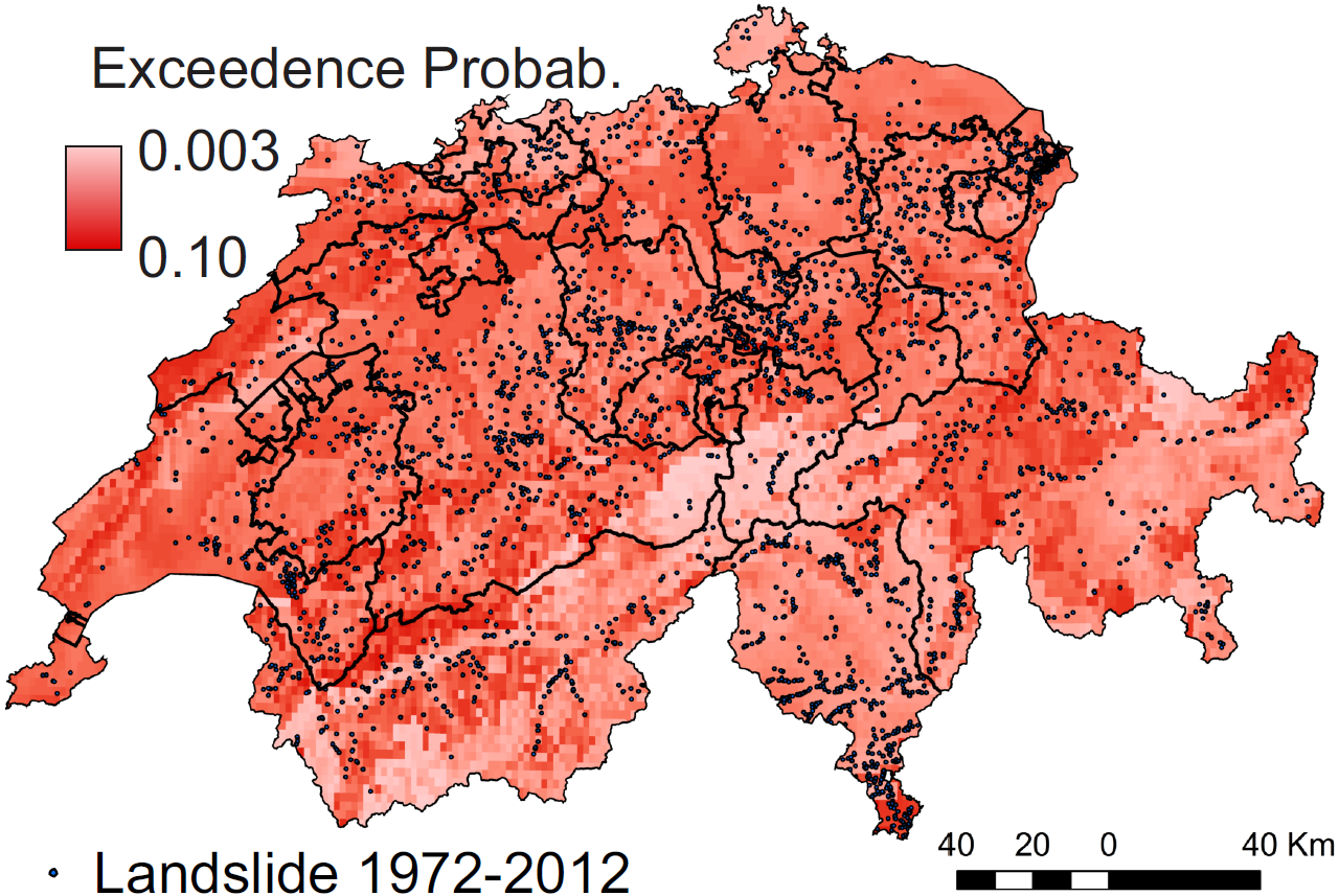
First, we developed rainfall thresholds for shallow landslides in Switzerland with a daily gridded dataset (RhiresD, Meteoswiss) and the WSL landslide damage dataset for the period 1972-2012 using a robust statistical method based on ROC curves. We looked at different precipitation characteristics (maximum depth, peak intensity, duration, etc.) and their combination in the form of ID (intensity-duration) thresholds. We assessed the improvement of the performance of rainfall thresholds by regionalisation based on mean daily precipitation and land surface erodibility, and we provided a thorough validation of the rainfall threshold models. This work was the first such analysis over entire Switzerland and provides a reference for further studies in rainfall triggering at daily timescales (Leonarduzzi et al. 2017).
Second, we provided a comprehensive data-driven assessment of the effects of rainfall temporal resolution (hourly versus daily) and the sensitivity to two other important aspects: the normalisation of rainfall, which accounts for local climatology, and the inclusion of antecedent rainfall as a proxy of soil water state prior to landsliding. Using the same landslide inventory with over 3800 events and several daily and hourly, station, and gridded rainfall datasets, we showed that although hourly rainfall does give best predictive performance for landslides, the benefits can be masked by the higher uncertainties connected to using short records. We also showed the direct benefits of normalisation and the predictive skill in antecedent rainfall as a proxy of soil wetness state (Leonarduzzi et al. 2020).
Leonarduzzi, E., P. Molnar, and B.W. McArdell (2017). external page Predictive performance of rainfall thresholds for shallow landslides in Switzerland from gridded daily data, Water Resour. Res., 53, https://doi.org/10.1002/2017WR021044
Leonarduzzi, E. and Molnar, P. (2020). external page Deriving rainfall thresholds for landsliding at the regional scale: daily and hourly resolutions, normalisation, and antecedent rainfall, Nat. Hazards Earth Syst. Sci., 20, 2905–2919, https://doi.org/10.5194/nhess-20-2905-2020
Testing the effect of subgrid variability in coarse-resolution models
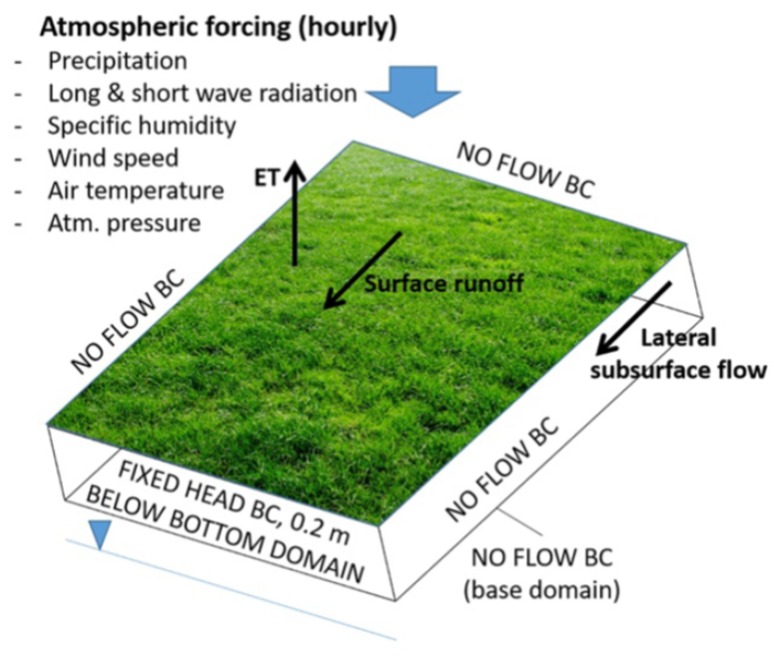
In coarse resolution hydrological models we often ignore the fact that hydrological processes may vary within the computational grid. In this extensive numerical work conducted in a collabration between ETH and the Colorado School of Mines, we quantified the effect of such subgrid heterogeneities in topography and soil thickness on hydrology and slope stability. The presence of subgrid side slope was shown to be most important, leading to large underestimation of runoff, affecting lateral flows and the spatial distribution of soil moisture, and overestimating slope stability. This research raised attention to the need to include subgrid effects in coarse-scale hydrological predictions, especially in applications that involve soil moisture for example for slope stability assessment.
Leonarduzzi, E., Maxwell, R.M., Mirus, B.B., and Molnar, P., (2021). external page Numerical analysis of the effect of subgrid variability in a physically based hydrological model on runoff, soil moisture, and slope stability. Water Resour Res, 57, e2020WR027326, https://doi.org/10.1029/2020WR027326
Landslide prediction with physically-based and probabilistic approaches
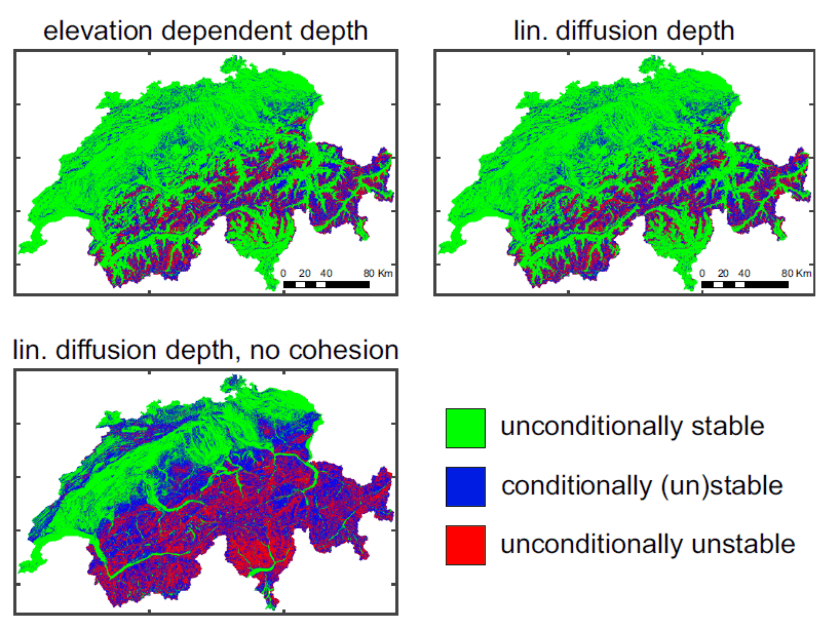
In this research we compared two methods (physically-based and probabilistic) for the prediction of shallow rainfall-induced landslides in an application to Switzerland, with a specific focus on the value of antecedent soil wetness. First, we showed that landslide susceptibility predicted by the factor of safety in the infinite slope model is strongly dependent on soil data inputs, limiting the hydrologically active range where landslides can occur to only ~20 % of the area with typical soil parameters and soil depth models. Second, the physically-based approach with a coarse resolution model setup (TerrSysMP) 12.5×12.5 km downscaled to 25×25 m with the Topographic Wetness Index to provide water table simulations for the infinite slope model did not succeed in predicting local scale landsliding satisfactorily, despite spatial downscaling. We argued in this work that this is due to inadequacy of the infinite slope model, soil parameter uncertainty, and the coarse resolution of the hydrological model. Third, soil saturation estimates provided by a higher resolution 500×500 m conceptual hydrological model (PREVAH) provided added value to rainfall threshold curves for landslide prediction in the probabilistic approach, with potential to reduce false alarms and misses. This work shows the potential of combined physically-based hydrological-geotechnical modelling, but also the need to overcome problems of model resolution, parameter constraints, and landslide validation for successful prediction at regional scales.
Leonarduzzi, E., McArdell, B. W., and Molnar, P., (2021). external page Rainfall-induced shallow landslides and soil wetness: comparison of physically-based and probabilistic predictions, Hydrol. Earth Syst. Sci., 25, 5937–5950, https://doi.org/10.5194/hess-25-5937-2021