Rain Intensity Relations to Air Temperature
Dates: 2012-2014
Principal Investigators: Peter Molnar, Nadav Peleg, Simone Fatichi
Rainfall intensity changes with air temperature at stations
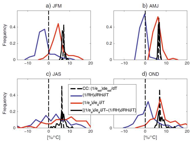
Extreme precipitation is expected to increase with warming at rates similar to or greater than the water vapour holding capacity of the air at ~7% °C−1, the so-called Clausius–Clapeyron (CC) rate, in some studies 2CC rates are reported. We investigated the CC rates using 30 years of 10-min and 1-hr data from 59 stations in Switzerland, and show that storm type mixing may exaggerate the relation of precipitation intensity to air temperature. For example, the peak 10-min intensities during an event increase at 6.9% °C−1 in stratiform rain, 9.3% °C−1 in convective rain, and 13.0% °C−1 when all events were mixed. 2CC rates reported by other studies were an exception in our data set, even in convective rain. We showed a large spatial variability in scaling rates across Switzerland, which suggests that both local (orographic) and regional effects limit moisture supply and availability in Alpine environments, especially in mountain valleys. Results also showed a marked seasonality of climatic changes with a trend toward warmer, clearer, and drier near‐surface atmosphere strengthening from January to June. During this period considerable negative trends in relative humidity were detected. An abrupt shift in climatic trends occurs during the month of July, after which warming trends were considerably smaller and relative humidity remained almost constant or increased. The strong seasonality and diurnal variability of changes in near‐surface meteorology over the last three decades in Switzerland warns against climate change impact assessments at local scale that consider uniform changes in air temperature and assume CC scaling for near‐surface humidity.
Molnar, P., Fatichi, S., Gaál, L., Szolgay, J., and Burlando, P. (2015), external page Storm type effects on super Clausius–Clapeyron scaling of intense rainstorm properties with air temperature, Hydrol. Earth Syst. Sci., 19, 1753–1766, https://doi.org/10.5194/hess-19-1753-2015.
Fatichi, S., P. Molnar, T. Mastrotheodoros, and P. Burlando (2015), external page Diurnal and seasonal changes in near-surface humidity in a complex orography, J. Geophys. Res. Atmos., 120, 2358–2374, doi:10.1002/2014JD022537.
Intensification of convective rain from weather radar
Convective rain storm area and intensity may also change with air temperature in ways which are difficult to detect from station data. In this research we used high spatial–temporal resolution (1-km, 5-min) estimates from a uniquely long weather radar record (24 years) coupled with near-surface air temperature over the eastern Mediterranean to detect changes in areal storm properties with air temperature. We show that peak intensity of individual convective rain cells increased with temperature, but at a lower rate than the 7%°C−1 scaling expected from the Clausius–Clapeyron relation, while the area of the individual convective rain cells slightly decreased or remained unchanged. The areal convective rainfall was found to increase with warmer temperatures, whereas the areal nonconvective rainfall decreased. This suggests an enhanced moisture convergence toward the convective rain cells. Limitations in the atmospheric moisture availability when shifting from Mediterranean to semiarid climates were detected and explain the suppression of the intensity of the convective rain cells when moving toward drier regions.
Peleg, N., F. Marra, S. Fatichi, P. Molnar, E. Morin, A. Sharma, and P. Burlando (2018). external page Intensification of convective rain cells at warmer temperatures observed from high-resolution weather radar data. J. Hydrometeor., 19, 715–726, https://doi.org/10.1175/JHM-D-17-0158.1.